Central Meteorological Observatory: There is an obvious cooling process in Jiangnan and South China, and it is rainy and rainy in the south.
CCTV News:The Central Meteorological Observatory issued a weather bulletin. During the day, there was moderate to heavy rain in Hunan, and small to medium snow in Xinjiang, Shaanxi and Henan. It is expected that there will be strong winds and cool weather in the central and eastern regions in the next three days, and attention will be paid to the impact on simple facilities, energy supply, maritime shipping, etc. Low temperature and rainy weather in the eastern part of southwest China, Jiangnan and South China; The rainy and snowy weather in northern Xinjiang is concerned about the impact on transportation, agriculture and animal husbandry.
First, the weather situation
1. moderate to heavy rain occurred in Hunan and other places. Snowfall occurred in Xinjiang and Henan, Shaanxi.
During the day today, moderate to heavy rain occurred in central Hunan and other places, and small to medium snow and local heavy snow occurred in Xinjiang along the Tianshan Mountains and parts of northern Xinjiang, central and northern Shaanxi, and western Henan.
2.Significant cooling has occurred in Gansu, Shaanxi and other places
At 16 o’clock today, compared with 16 o’clock yesterday, the temperature dropped by 4 ~ 8℃ in parts of central and western Gansu, central and southern Shaanxi, Sichuan Basin, Huanghuai, Jianghan, central and western Jiangnan and eastern South China.
Second, the key weather forecast
1. There is an obvious cooling process in Jiangnan and South China.
From the night of the 11th to the 13th, due to the influence of strong cold air, the minimum temperature or daily average temperature in Huanghuai, Jianghuai, the eastern part of Southwest China, Jiangnan, South China and the central and eastern parts of Qinghai-Tibet Plateau dropped by 4 ~ 8℃ cumulatively, among which the temperature in southwest Guangxi dropped by 10 ~ 12℃, and there were northerly winds of 4 ~ 6 in some areas. The lowest temperature appears on the morning of 13th to 14th, and the lowest temperature 0℃ line is located in the line from the south of Huanghuai to the north of Jianghuai. The lowest temperature in Jianghan, the south of Jianghuai, the north and west of Jiangnan and the north and east of Guizhou will drop to 2 ~ 4℃ (see Figure 1).
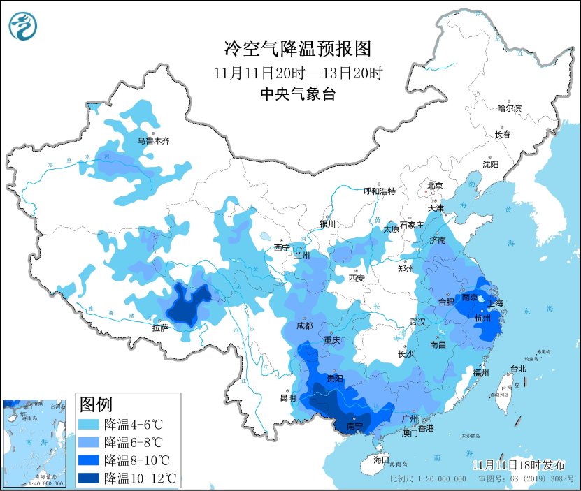
Figure 1 National cold air cooling forecast map (November 11
20: 00 -13: 00)
From 20: 00 on the 11th to 20: 00 on the 12th, some areas in northern Xinjiang, Qinghai, southeast coastal areas of Fujian, Taiwan Province Island and other places will have strong winds of 5-6 grades and gusts of 7-8 grades; There will be strong winds of 7-8 grades and gusts of 9 grades in the southern part of the East China Sea, the Taiwan Province Strait, the east of Taiwan Province, bashi channel, the northern and central South China Sea, and Beibu Gulf, among which the winds in parts of the Taiwan Province Strait can reach 9 grades and gusts of 10 grades. From 20: 00 on the 12 th to 20: 00 on the 13 th, there will be strong winds with 5~6 grades and gusts of 7~8 in western and northern Tibet, southern Qinghai, southeastern Fujian coastal areas and Taiwan Province Island; There will be strong winds of 7-8 grades and gusts of 9 grades in the southern part of the Yellow Sea, most of the East China Sea, Taiwan Province Strait, east of Taiwan Province, bashi channel, northern and central South China Sea, Beibu Gulf and Qiongzhou Strait, among which the winds in parts of the Taiwan Province Strait can reach 9 grades and gusts of 10 grades.The Central Meteorological Observatory continued to issue a gale blue warning at 18: 00 on November 11.(See Figures 2 and 3.)。
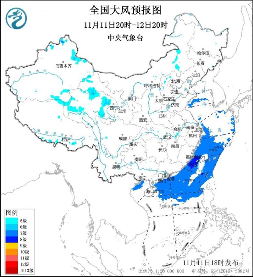
Figure 2 National gale forecast map (20: 00 on November 11th-20: 00 on December 12th)
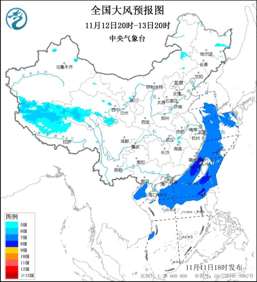
Figure 3 National gale forecast map (20: 00 on November 12-20: 00 on November 13)
2. It’s rainy in the south.
From the night of 11th to 15th, it was rainy in the eastern part of Southwest China, Jianghan, Jiangnan and South China. Among them, from the night of the 11th to the 12th, there were moderate to heavy rains and local heavy rains in Sichuan Basin, southern Yunnan, southwestern Guangxi and Hainan Island.
In addition, from the night of the 11th to the 14th, there were small to medium snow or sleet in parts of northern Xinjiang and along the Tianshan Mountains, and there was heavy snow locally.
Third, the specific forecast for the next three days
From 20: 00 on November 11 to 20: 00 on December 12,There is light snow or sleet in parts of Xinjiang along the Tianshan Mountains, central and eastern Tibet, northern and southeastern Qinghai, central and southern Gansu and Hexi, Shandong Peninsula and northern Sichuan Plateau. There is moderate to heavy rain in parts of Sichuan Basin, southern Guizhou, southwestern Hunan and Hainan Island, and there is heavy rain (50 ~ 65 mm) in the local area. There are 5 ~ 6 winds in parts of Liaodong Peninsula, northern Qinghai, northern Hebei, Shandong Peninsula, central Sichuan Basin and eastern Zhejiang. There are strong winds of 7-8 grades and gusts of 9 grades in the south of the East China Sea, Taiwan Province Strait, east of Taiwan Province, bashi channel, northern and central South China Sea and Beibu Gulf (see Figure 4).
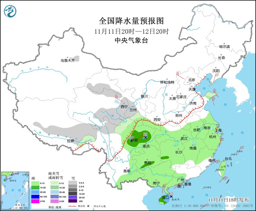
Figure 4 National Precipitation Forecast Chart (20: 00 on November 11th-20: 00 on December 12th)
From 20: 00 on November 12 to 20: 00 on November 13,There is light snow or sleet in parts of northern Xinjiang and southern Gansu. Among them, there is moderate to heavy snow (5 ~ 7 mm) in parts of Altay and Ili Valley in Xinjiang. There are small to moderate rains in parts of the southeastern part of Southwest China, western Jiangnan, northwestern South China and Hainan Island. There are 4 ~ 6 winds in parts of central Inner Mongolia, northeastern Heilongjiang, Liaodong Peninsula, Shandong Peninsula, eastern Zhejiang and southeastern Guangxi. There will be 6-8 winds in the Bohai Sea, the Yellow Sea, most of the East China Sea and parts of the Taiwan Province Strait, and the gust can reach 9 (see Figure 5).
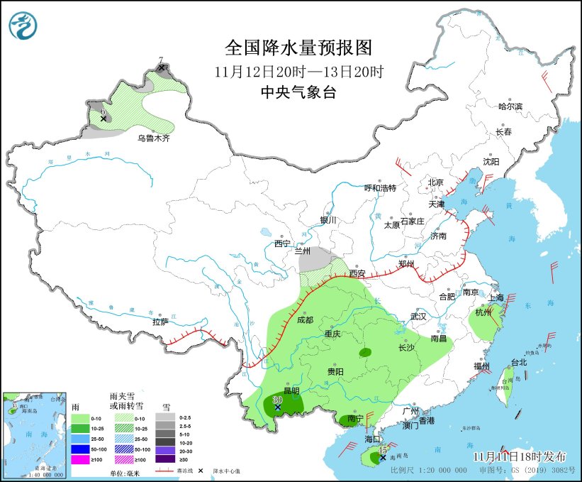
Figure 5 National Precipitation Forecast Chart (from 20: 00 on November 12 to 20: 00 on November 13)
From 20: 00 on November 13th to 20: 00 on November 14th,There are small to medium snow or sleet in parts of northern Xinjiang and central Qinghai. Among them, there are moderate to heavy snow (5 ~ 8 mm) in parts of Xinjiang along Tianshan Mountain. There are small to moderate rains in parts of central and southern Yunnan, southern Hunan, northern South China and Hainan Island. There are 4 ~ 6 winds in parts of western and central Inner Mongolia, northeastern Heilongjiang, Liaodong Peninsula, Shandong Peninsula, eastern Zhejiang and southeastern Guangxi. There will be 6 ~ 8 winds in Beibu Gulf, bashi channel and the central and northern South China Sea, and the gust can reach 9 (see Figure 6).
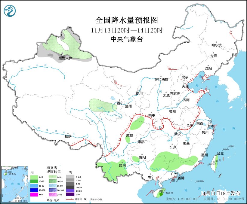
Figure 6 National Precipitation Forecast Chart (from 20: 00 on November 13th to 20: 00 on November 14th)