Cold wave, blizzard and strong wind, three warnings continue! The local temperature drop in the middle and lower reaches of the Yangtze River and the north is over 16℃
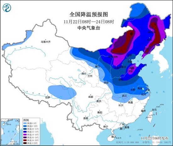
China Weather Network News "Cold Wave+Blizzard+Gale" three warnings continue! The second cold wave has already started this winter. This cold wave will affect China from west to east three days from now (November 22 to 24). The temperature in some areas in the north will drop sharply, and the maximum drop will exceed 16℃. The northeast will welcome the third round of heavy snowfall this winter, and there will be heavy snow in the local area.
The cold wave moves eastward and southward step by step, and the warm pattern in the early stage will be reversed, with strong winds, cooling, rain and snow coming on stage again and again. During this cold wave, there will be a sharp cooling in the north, and the temperature in most areas will reach the low point of this cooling process on Friday.
Affected by the cold wave, it is estimated that the temperature in the middle and lower reaches of the Yangtze River and its north will drop by 6 ~ 10℃ from November 21st to 24th, among which the temperature in Inner Mongolia, Northeast China, western and northern North China, central and eastern Huanghuai and other places will drop by 12 ~ 16℃, and the temperature drop in some areas such as central and eastern Inner Mongolia and eastern Northeast China can exceed 16℃.
The main period of gale cooling is from 22nd to 24th; After the cold wave, the lowest temperature 0℃ line will be located in the middle of Jiangsu and Anhui, south-central Henan, southwestern Shaanxi, southeastern Gansu and other places, and the lowest temperature in eastern Inner Mongolia and most parts of Heilongjiang will drop below -20℃, and the local temperature can reach below -30℃. Most of the above areas are accompanied by northerly winds of 4 ~ 6 grades, gusts of 7 ~ 8 grades, and local grades of 9 grades. Some areas in western Inner Mongolia and Ningxia have dusty weather; From 23rd to 25th, there will be 6-8 gale in the eastern and southern seas of China, with gusts of 9-10.

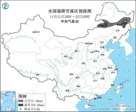
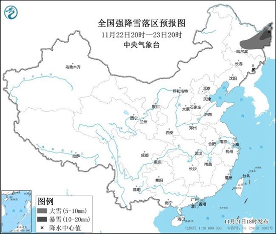
The rain and snow weather brought by the cold wave is mainly concentrated in the north-north, especially in the central and eastern Inner Mongolia and the northeast, and the main impact period is from the night of the 21st to the 22nd, which is the third round of heavy snowfall affecting the northeast since this winter. It is estimated that from 08: 00 on November 22 to 08: 00 on November 23, there will be heavy blizzards in parts of eastern Inner Mongolia, central and eastern Heilongjiang, northern Jilin and Changbai Mountain, among which there will be heavy blizzards (20 ~ 22 mm) in central Heilongjiang; The depth of newly added snow in the above areas is 6 ~ 12 cm, and the local area can reach more than 16 cm.


China Weather Network reminds that the heavy snowfall in Northeast China overlaps with the previous period, so relevant departments and the public should pay attention to clear the snow in time to prevent the secondary disasters that may be caused by heavy snowfall in advance. Among them, some areas in eastern Inner Mongolia, central and eastern Heilongjiang, eastern Jilin and other places are at risk of snowstorm, low-temperature rain and snow freezing and cold wave disasters. Snow and ice on the road surface may easily lead to traffic congestion or accidents, and snow may lead to the collapse of local geothermal sheds and livestock pens, which need to be cleaned in time.